

2. Politecnico Di Milano, Milano 20133;
3. University of Twente, Enschede 7514 AE
Water is a vital natural resource for human livelihood and the entire ecosystem including agriculture, and is also an important basic resource for the sustainable development of economy and society globally and regionally. With rapid development in economy and climate change, the contradiction between increasing demand for water resource due to increase in population, agriculture, and other economic activities and shortage in water supply is becoming more and more serious in the countries relevant to the Belt and Road Initiative. The countries relevant to the Belt and Road Initiative host about 70% population of the world, while the possession of water resource per capita in this area is only 36% of the world average. This leads to the pressure in demand for water resource in this region which is much higher than the rest of the world.
Assessment of fresh water resources and their effective and sustainable use faces multiple and very diverse challenges in the Belt and Road Countries in Asia, Europe, and Africa. In the arid and semi-arid Central Asia, serious lack of water resources and desertification, particularly large areas affected by secondary salinization due to the mismanagement of irrigation, is a major and complex challenge. Northern Africa, including the Sahel, vegetation degradation and land desertification is very serious due to climate change, population growth, over grazing, excessive burning, agricultural development, and others. Southern China, South Asia, and Southeastern Asia often suffer from droughts and floods because of the uneven distribution of seasonal precipitation and anomalies in Asian monsoon. Irrigated agriculture is very important for all countries in this region. Use of water by agriculture needs to be efficient and effective, which will ensure sustainable agricultural development and food security, under water stress conditions. Rapid changes in glaciers, snow cover and lake area in the High Mountain Asia are influenced by global warming and human activities, and in return have a large impact on land-atmosphere interactions and, therefore, on weather and climate. Such changes and interactions further have decisive impact on the security and sustainable development of the society and economy in the downstream area. The economic development and construction of large infrastructures may alter regional water resource and water use. This trend will very likely increase the water demand and the likelihood of conflicts about sharing water in multi-national watersheds in the Belt and Road countries.
Ground-and satellites-based Earth observations together with various modelling efforts can provide essential information on water resources and water use critical for informed decision-making. The DBAR-WATER theme under the framework of Digital Belt and Road (DBAR) is a joint effort to be carried out through close and effective cooperation among scientists from water resource and water use sector in the countries of the Belt and Road region under the framework of the DBAR Science Program by building joint platforms, research centers, and research projects among corresponding research institutions in the Belt and Road countries.
Science driven force
The shortage and uneven distribution of water resources, frequent drought and flood disasters, conflicts in demand and availability of water, and glacier melting are the main problems in water resources in the area of the Belt and Road Initiative. Adequate solutions to these problems demands advances in the following challenges: (a) Drought detection; (b) Flood monitoring and early warning; (c) Adaptation of water management systems; (d) Water productivity of agriculture; (e) Hydrosphere processes and climate; (f) High elevation hydrology. Spatially and temporally continuous information on water resources from space observations will help us to understand the spatial distribution, dynamic changes, water use efficiency, and driving mechanism of change and variability in water resources, towards mitigation of impacts on and conflicts about the availability of water resources in the Belt and Road countries. The improvement of water use efficiency and water resources management will be helpful to increase the water productivity and to combat desertification and land degradation in the situation of water scarcity. The research on the water cycle and its interactions with climate change, with special attention for hydrological processes in High Mountain Asia, will be beneficial towards better understanding of the driving mechanism of water resources changes in the context of climate change. Satellite-based drought and flood monitoring can capture the process of development of drought and flood across a range of spatial scales, which can contribute to early warning and the mitigation of loss caused by drought and flood disasters.
Societal impacts
DBAR-WATER research can provide expertise, information systems, and datasets to contribute to the UN Sustainable Development Goal (SDG) 6 to "ensure availability and sustainable management of water and sanitation for all".
Water as a critical importance to people and society, is one of GEOSS nine Societal Benefit Areas (SBA). The aim for GEOSS Water is to produce comprehensive sets of data and information products to support decision-making for efficient management of the world's water resources, based on coordinated, sustained observations of the water cycle on multiple scales. The research content for DBAR Water can support the aim of GEOSS water. In addition, DBARWATER also supports other international agenda, such as ICSU Future Earth Programme, Global Water Partnership, GEWEX new era plans, and regional water communities.
Objective
The objective of the DBAR-WATER theme is to solve the problems related to water resources in the area of the Belt and Road using Earth Observation technique, through the studies on several crucial issues, including: to study the water cycle, to analyze the spatial-temporal distribution of water resources and their variability as well as its driving mechanism, to evaluate the water use efficiency and water productivity, to monitor and predict droughts and floods events, and to improve the effectiveness and fairness of water resources management. This will require investments in capacity building on Earth observation for water resources assessment and management in the Belt and Road countries, by strengthening at the same time international cooperation and communication among partner countries and regions. Such efforts will create scientific evidence and essential information towards sustainable use of water resource in the Belt and Road countries.
Progress Involved countriesThe involved countries currently include Vietnam, Thailand, Iran, Pakistan, India, Malaysia, Mongolia, Morocco, Kenya, Tunisia, Uganda, Italy, the Netherlands, and other Asian, African, and European countries. The Co-Chairs of DBAR-WATER Working Group are Prof. Jia Li from Institute of Remote Sensing and Digital Earth (RADI), Chinese Academy of Sciences (CAS), Prof. Marco Mancini from Politecnico DI Milano of Italy, and Prof. Bob Su from University of Twente of the Netherlands. Partners in DBAR-WATER Working Group include Politecnico DI Milano (Italy), University of Twente, Delft University of Technology (the Netherlands), Chouaib Doukkali University (Morocco), UNESCO Institute for Water Education—UNESCO-IHE (the Netherlands), International GEWEX Office, University of Peshawar (Pakistan), National University of Mongolia (Mongolia), National Institute of Technology (India), Regional Centre for Mapping of Resources for DevelopmentRCMRD (Kenya), Observatory of the Sahara and Sahel-OSS (Tunisia), Agrrometeorology, Hydrology, Meteorology regional centereAGRHYMET (Niger), Makerere University (Uganda), Khon Kaen University (Thailand), Ho Chi Minh City University of Technology (Vietnam), Universiti Teknologi (Malaysia), Tarbiat Modares University (Iran), Nanjing Institute of Geography and Limnology (NIGLAS, CAS), China Institute of Water Resources and Hydropower Research (China), Tsinghua University (China), and other institutions. Cooperation with other relevant countries is under development.
Progress and future plan Research progressThe Working Group of the DBAR-WATER Theme has defined the following thematic activities grouped as Tasks and some initial progresses have been made.
Task 1: General water resource mapping
This task will develop algorithms to create time series of water resource components using satellite observations, such as precipitation, evapotranspiration, soil moisture, lake and glacier areas, snow cover, water quality, etc. General water resource mapping will provide data to support the studies in other tasks described below (Figure 1).

|
| Figure 1 Water balance in the Belt and Road Area. (a) Average annual precipitation (P) in the Belt and Road Area using GPCP precipitation data from 1979 to 2015. (b) Average annual evapotranspiration (ET) in the Belt and Road Area using ETMonitor data from 2008 to 2013. (c) Average water budget (P-ET) in the Belt and Road Area using GPCP precipitation and ETMonitor evapotranspiration data from 2008 to 2013 |
Task 2: Hydrosphere processes and climate
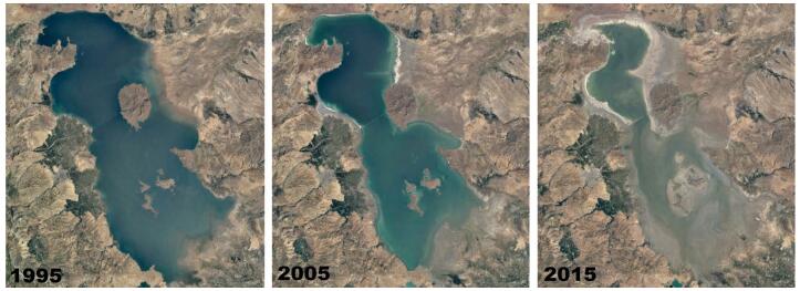
This task will study the interaction between the hydrosphere processes and climate through analyzing the spatial and temporal distributions and changes in water related variables in some typical basins, and clarify the main control factors of different hydrological processes and feedback to climate. This research will provide scientific basis for regional water resources management (Figure 2).
|
| Figure 2 Severe drought and increased demand for irrigation water have been gradually shrinking the Urmia lake in north-west Iran over the past few decades |
Task 3: Adaptation of water management systems
This task will analyze the temporal and spatial characteristics of water resources using multi-source earth observation data in key river basins in the countries of the Belt and Road Initiative, in particular in the regions where specific economic plans have been established. Water availability, water use, water re-allocation, and water collection in accordance to the new circumstance due to economic development will be evaluated. This better understanding of vulnerabilities will lead to identify options to mitigate or remedy the underlying factors of vulnerabilities towards viable options for the adaptation of water management systems (Figure 3).

|
| Figure 3 Oum-Er-Rbia Basin (Morocco): Yearly evolution of actual ET in the Doukkala irrigation scheme and current water management with water releases largely in excess of irrigation water requirements (IWR = ETC -P) in autumn and winter and insufficient to meet requirements in spring and summer. (a) Actual ET (MODIS) of Tadla and Doukala irrigated areas in Oum-Er-Rbia Basin (Morocco) in March 2014.(b) Doukkala irrigation scheme: Water inflows and outflows Al Massira dam vs. maximum (ETc) and actual (ETr) evapotranspiration within the Doukkala irrigated area |
Task 4: Water productivity of agriculture
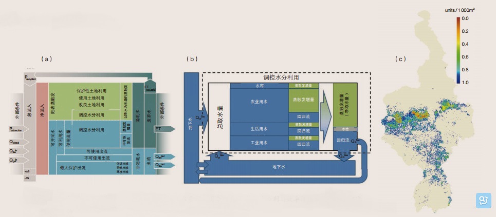
This task will apply middle-high resolution remote sensing data to a process based model to assess crop water use, water productivity and water accounting in the Belt and Road countries. Improving water productivity seeks to get the highest benefits from water and hence can be viewed as a major contributor to water saving. Solutions will be proposed including alternative crops and advanced irrigation methods (Figure 4).
|
| Figure 4 Water accounting approach and water productivity assessment. (a) Water accounting: Resource base sheet. (b) Water accounting: Utilized flow sheet. (c) Water productivity of the Nile Basin: Livestock production per 103 m3 a-1 ET |
Task 5: Drought and flood
The task will develop methods and early warning system for drought and flood monitoring using satellite observations in the area of the Belt and Road, analyze the drought and flood frequency, impact and driving mechanism, and evaluate the impact of flood and drought on agricultural production and ecological environment.
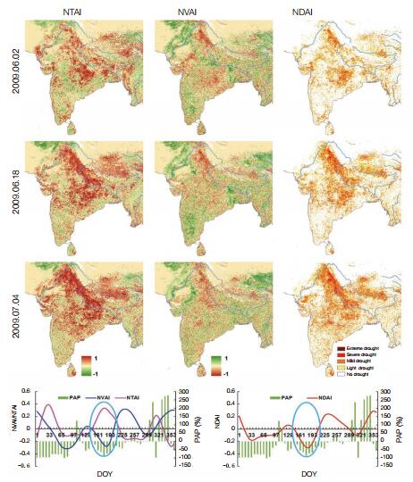
Drought monitoring for Ganges river basin in India in summer of 2009 using MODIS vegetation and temperature data. NTAI, NVAI, and NDAI are normalized temperature anomaly index, normalized vegetation anomaly index, and normalized drought anomaly index, respectively. During the drought period, temperature anomaly is mainly occurred in the north of India, while the vegetation anomaly is not as serious as the temperature anomaly due to irrigation in the agricultural area (Figure 5).
|
| Figure 5 Drought monitoring for Ganges river basin in India in summer of 2009 |
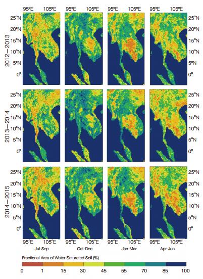
The retrievals of water saturated surface (WSS) area from microwave satellite data can delineate the surface wetness conditions and their dynamics, thus it can be used for assess the region under high risk of flooding together with precipitation forecasting—a useful indicator for flood early warning (Figure 6).
|
| Figure 6 Flood early warning (Southeast Asia) |
Task 6: High elevation hydrology
This task will develop methods to improve the retrieval accuracy of several crucial water cycle variables using remote sensing data over complex land surfaces, and to analyze the impacts of glacier changes on regional water resources and ecological environment in the high mountain Asia (HMA) under climate change and human activities (Figure 7).

|
| Figure 7 Tibetan Plateau can be divided into three areas according to the relationships of glacier thickness and lake level. Lake level rises with decreasing of glacier thickness in Pattern 1 around Tanggula Mountains, lake level decreases with decreasing of glacier thickness in Pattern 2 around the western Nyainqentanglha mountains, Himalaya mountains, and Gangdise mountains, and lake level rises with increasing of glacier thickness in Pattern 3 around Kunlun Mountains |
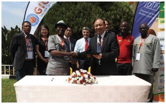
A special session "DBAR and AARSE: New horizons for the cooperation between Africa and China" was jointly organized by Prof. Jia Li and Prof. Menenti from RADI-CAS and the secretary general Prof. Kamal Labbassi from Chouaib Doukkali University of Morocco at the 11st African Association of Remote Sensing of the Environment International Conference (AARSE2016) in Kampala, Uganda in October 2016, cooperation memorandums of understanding between DBAR and AARSE were signed to develop the cooperation plan in sustainable development and digital earth research using Earth observation technique (Figure 8).
|
| Figure 8 Prof. Guo Huadong, the Chair of DBAR, and Prof. Olajide Kufoniyi, the Chair of AARSE, signed the cooperation memorandum of understanding in Kampala, Uganda in October 2016. |
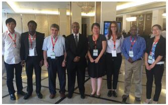
A new project on understanding the Driving Mechanisms of Land Use and Cover Change in the Sahel: Impacts and Responses" (DIMECLUES) under the framework of NSFC and UNEP has just started that involves three partners from Tunisia, Kenya, and Niger, which will study the Sahel land degradation and ecological environment change to enhance the regional soil and water conservation and ecosystem management using multi-source remote sensing data and other auxiliary data (Figure 9). A cooperative project on drought and flood monitoring using satellite data in Thailand is initiated in 2017, through which an information platform will be built for real-time monitoring the soil water moisture and land surface water loss via evapotranspiration. In addition, the cooperation researches about water resource with Italy, Morocco and other countries are underway (Figure 10).
|
| Figure 9 Kick off meeting of the DIMECLUES (NSFC-UNEP) project in Kampala, Uganda in October 2016 |
|
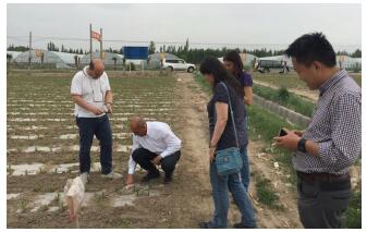
| Figure 10 Prof. Kamal Labbassi from Chouaib Doukkali University of Morocco and prof. Marco Mancini from Politecnico DI Milano of Italy visited the agricultural field in the northwest China in May 2016 |
Specific research activities for each partner country related to one or more above mentioned themes are under development with the partners from each relevant country. RADI has made agreements with the partner institutions in all cooperative countries to sign the Memorandum of Understanding. The first workshop of DBAR-WATER is planned in 2017.
Ideas and thoughts about DBAR from each partner GEWEX: Dr. Peter van Oevelen, Director, International GEWEX Office, USA

|
| Dr. ir Peter J. van Oevelen is the director of the International GEWEX Project Office since 2008. His research interests and expertise involve earth observation in the broadest sense and climate and weather processes with an emphasis on water. He is currently actively involved in the WCRP Grand Challenge on Water for the Food Baskets |
The research initiatives and foci of DBAR-WATER fit perfectly with the objectives by the global energy and water exchanges (GEWEX) project of the world climate research programme (WCRP). More specifically, it builds upon expertise from GEWEX's Regional Hydroclimate Projects such as MAHASRI, NEESPI, and GAME (in Asia), AMMA (in West Africa). It also contribute to a great extent to the WCRP Grand Challenge in Water which is called the Water for the Food Baskets of the World that focuses on the human dimension in climate and weather processes related to agricultural production from both a historical, current (process understanding) as well as future (predictive) perspective. This grand challenge initially will focus on three main regions in North America, Europe, and Asia. GEWEX has supported the development of global data sets on land cover and land use starting with ISCLSCP to the current global data products such as GPCP, SRB, ISCCP, LandFlux, etc. (for a complete overview visit gewex.org) that cover the various state variable and fluxes that are relevant to our understanding of the earth's process and its weather and climate. To continue the progress within projects such as GEWEX contributions from projects such as DBAR-WATER are vital as they address both improved observations, better process descriptions as well as local and regional evaluation of the available global data products relevant to water and water related processes.
UNESCO-IHE: Prof. Wim Bastiaanssen, The Netherlands
|
| Prof. Dr. Wim G. M. Bastiaanssen is a senior remote sensing expert with a specialization in agricultural water management. With Ph.D. students, he conducts research on determining earth surface hydrological and water management processes from satellite measurements including rainfall, evapotranspiration, soil moisture, biomass production, crop water productivity, surface runoff, withdrawals for irrigation and wetlands and groundwater interactions. Wim Bastiaanssen is the lead developer of Water Accounting Plus (WA+). Through the repository www.wateraccounting.org, Wim produces open access water accounts for river basins, that can be used by all stakeholders involved in the strategic planning of scarce water resources |
The DBAR-WATER cooperation is a good initiative to provide a better basis for the water science and dissemination of water related knowledge in an international context. Many countries in Central and East Asia are plagued with water scarcity and have the unavoidable challenge to increase water security, i.e. create sufficient water resources for productive activities, ecosystems, and livelihoods. Such challenge requires an international collaboration, and I believe that an international standard on water accounting is a first pre-requisite. Standardized data on water budgets, land use, and local availability of water resources in streams, lakes, reservoirs, and aquifers is essential for making longer term water management plans, both for national river systems as well as for transboundary rivers. DBAR-WATER can work together with the partnership for water accounting that consists of several United Nations partners and IWMI (www.wateraccounting.org) to create a standard reporting system on water resources. China has an excellent space program and good hydrologists. I see a natural exchange of tools and models, with satellite measurements and experimental data collected during large scale field experiments on water and energy balances. DBAR-WATER could facilitate in the formation of a Water Accounting Centre as part of RADI or CAS.
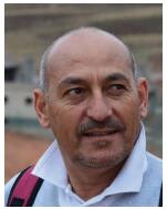
Morocco: Prof. Kamal Labbassi, Chouaib Doukkali University
|
| Prof. Kamal Labbassi is a Professor at the Chouaib Doukkali University and Secretary General of the African Association of Remote Sensing of the Environment. His current research focuses on remote sensing and applications in geosciences, ecosystem, and water resources studies as well as agriculture and irrigation in dry context |
Owing to its semi-arid climate, Morocco suffers heavily from climate change. According to present forecasts, the continuing desertification is menacing about 80% of the country. There is the danger that the country moves on a critical water supply situation, in which long and severe drought spells and higher temperatures will characterize the climate. This shows the vital necessity to use available water resources as effectively as possible in order to avoid or at least mitigate the consequences of recurring droughts. This is particularly important for the water management in agricultural areas. Aware of this problem, the Moroccan government has implemented a strategy based on the development of water resources, by, among other things, the development of technical skills and applied scientific research. It is in this context that our research activities are integrated.
Aware that any scientific development consists of a confrontation and sharing of experience and knowledge with others parties in the same field, we believe that the DBAR initiative will be an opportunity to develop complementary capacities between different partners. Beyond this, a transfer of mutual technology, data sharing and information will be implemented.
The work plan and the thematic activities expressed in the DBAR science plan for the theme of water, fits perfectly with our research objectives. We hope to test, validate, and compare our research in other geographical contexts along the BAR region.
India: Prof. Ramakar Jha, National Institute of Technology (NIT)

|
| Dr. Ramakar Jha, Chair Professor in the Department of Civil Engineering, National Institute of Technology (NIT) Patna, is having more than 26 years of experience in the area of Hydrology and water resources engineering. Dr Jha has worked and is working as Country Co-ordinator and Principal Investigator for more than 20 International/National research and consultancy projects |
In India, floods and drought are significant phenomena observed in the recent past mostly due to climate change. To assess the uncertainty involved in occurrences of floods and droughts in Himalayan basins, the use of Earth observation data such as anomalies in soil moisture, precipitation, land surface temperature, and evapotranspiration losses on real time basis together with cropping pattern and elevation are very useful. Assessment of morphological changes in Ganga basin, including river hydraulic phenomena erosion and sedimentation, could be prioritized by using Earth observation data.
Water use efficiency is another important aspect, which could be studied using field observations substantiated by earth observation data. Moreover, the earth observation data (hyper-spectra) are very useful for assessment of water quality in reservoirs as well as large rivers like River Ganga. In India many programs are going on under the National Mission for Clean Ganga.
The following development under joint efforts among scientists/academicians of many countries from Asia and Europe under the DBAR-WATER framework is expected to provide solutions to resolve water related issues in India and other countries: (a) web-based models to provide solutions (for researchers); (b) GPS based Mobile apps for real time solution at river sites (Field engineers); (c) user friendly software and its use for capacity building programs (for students, field engineers, technical assistant and community at local level).
Mongdia: Prof. Altansukh Ochir, National University of Mongolia

|
| Dr. Ochir Altansukh is a professor at Department of Environment and Forest Engineering, School of Engineering and Applied Sciences, National University of Mongolia. His recent study focuses on estimation of most suitable sites for water harvesting pond using RS, GIS, and SMCA. Furthermore, he has experience on water quality assessment, river catchment area modeling, and surface water database development and mapping |
Due to high fluctuation of climate during the year (-45℃-+38℃), vulnerability to the climate change and vast territory with different natural zones of Mongolia, there are surface, ground water, and glacier melting issues are existing. For instance, different water availability in varies regions, southern region is less developed. However, most of economically valuable mining deposits are discovered in less water available region. Therefore, we need to make studies on water restoration, collection (harvesting), allocation, and exploring new aquifer to support socio-economic development, environmental sustainability in the southern region of Mongolia. Due to mining boom and over extraction of groundwater in Govi region, water table rapidly decreasing, and it is not fully monitored. Thus, maybe long distance water transportation system needs to build from north to south to sustain socio-economic-environmental life. In the western region of Mongolia, high elevation hydrology process is changing reason of rapid melting of glacier. All fresh waters from glacier are just run out. Therefore, water harvesting and storing technologies need to introduce.
Tasks defined by DBAR-WATER Working Group can assist us to solve aforesaid problems in Mongolia by developing integrated water resource policy of the bordering countries and data-sharing platform. Especially, Task 1 (General water resource mapping), Task 4 (Adaptation of water management systems), Task 6 (Drought and flood) will contribute to develop an integrated data-sharing system, to implement adaptation technology and to monitor water-related natural disasters. Moreover, Task 7 (High elevation hydrology) is also important to understand changes of a hydrological process in high altitude and its impact on low elevation. Based on pure scientific findings, we can solve our issues, collaboratively.
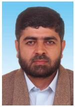
Pakistan: Dr. Atta-Ur Rahman, University of Peshawar
|
| Dr. Atta-ur Rahman is Associate Professor in the Department of Geography, University of Peshawar, Pakistan. He has outstanding contribution in the field of flood risk reduction and environmental impact assessment. He is closely working with international organizations on various projects of floods, drought, and water resource management and supervising research students in the field of water resource management and climate change. He is member of editorial board of reputed journals and has authored books and numerous research articles in prestigious journals |
In the B&R region, Pakistan is an important bordering country for China with rich water resources (surface, ground, and glaciers), exposure to water related disasters and a good network of rivers and canal systems that largely support the agriculture economy. Parallel to this, the country has a rich biological diversity with a wide variation in topography, which provides nourishment for glaciers and snow clad mountains of Himalayas, Hindu Kush and Karakorum. The country also receives ample precipitation during spring, summer, and winter from monsoon and western depressions that feed the river system for irrigation and hydro-power and also pose frequent risks of floods and droughts.
Pakistan is exposed to wide range of hydrological hazards where drought and floods are frequently occurring events. Due to the changing climate scenario, the frequency and intensity of extreme hydro-meteorological events further exacerbated. These are few challenging areas that need to be covered in DBAR-WATER group.
Trans-boundary water disputes and disaster is one of the challenging issues in Pakistan bordering countries. As the watersheds of trans-border rivers lie in the Hindu Kush, Himalayas and Karakorum mountains and recharge the rivers of China, Pakistan, Afghanistan, Kazakhstan, Nepal, Bangladesh, and India. These mountain systems host numerous valley glaciers, snow clad mountains, glacial lakes, and mega dams and receive ample amount of precipitation. This need to be made part of the DBAR-WATER mini-projects for bilateral cooperation and effective water resource management between the Belt and Road member countries.
The China-Pakistan Economic Corridor (CPEC) is an ongoing mega development project in Pakistan, aims to connect Gwadar port (south of Pakistan) to China via the Silk Road through a network of highways, railways, and pipe lines with a gross total cost of US$54 billion. However, CPEC is exposed to wide range of hydro-meteorological disasters. This need to be studied as a pilot integrated project under the B&R initiative. In the DBAR countries, the CPEC is an integrated case study that would reflect various opportunities and challenges relevant to the B&R Initiative, and CPEC could serve as a common platform for DBAR pilot researches that link various DBAR schemes/WGs together.
In DBAR-WATER group, outstanding scientists will help in exchanging innovative ideas and to encapsulate the same for the prosperity of Pakistan and enhance capacity of young scientists. The organization of training workshops, initiation of MS/Ph.D. fellowship programmes with RADI, faculty exchange program, and establishment of regional DBAR Water Centres of Excellence in B&R countries like Pakistan would be the most effective way to achieve the objectives of DBAR.
Vietnam: Dr. Vu Phan, Ho Chi Minh, City University of Technology (HCM-UT)

|
| Dr. Vu Hien Phan is currently a head of Department of Geomatics Engineering at Ho Chi Minh City University of Technology, Vietnam. His research interests involve exploiting earth observation data for monitoring water resource, environment and climate changes, and applying geospatial analysis for estimating relationships between environmental, climatic, and socio-economic factors in regional planning and socio-economic development |
Exploiting EO data in the area of hydrological sciences and water resources management is currently the modern and effective approach. Based on the EO data in combination with in-situ measurements, parameters of water cycle can be estimated such as precipitation, evapotranspiration, or permeability. Then, applications in drought assessment, flooding prediction, irrigation-water estimation for agricultural products, ecosystem-water balance, etc. can be deployed effectively. These applications are especially useful in Vietnam with agricultural production and biodiversity. Main agricultural products consist of rice, coffee, tea and tropical fruits. Therein approximately 50 percentage of total national rice yield is from the Mekong River delta. It essentially contributes to food security in Vietnam and on the world. Accordingly, water resources play an important role in agriculture in Vietnam, and to ensure water storage in production is really essential. Understanding and monitoring the water use productivity of the main crops is vital for the most effective use of water. Exploiting EO data can help to solve these problems effectively towards better management. That is also why we are interested in joining the DBAR-WATER program, in which we can share experiences and knowledge in EO applications in water resources in Vietnam with colleagues and scientists of ~65 countries.
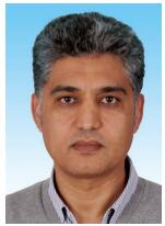
Tunisia: Dr. Nabil Ben Khatra, Observatory of the Sahara and Sahel (OSS)
|
| Dr. Nabil BEN Khatra is an agricultural engineer and Remote Sensing and GIS specialist with 23 years of experience in the development of environmental surveillance tools and associated knowledge management systems. He began his professional career working in the National Remote Sensing Center then at the Ministry of Environment (Tunisia). In 2003, he joined the OSS as M&E Expert and was appointed Environment Program Coordinator since 2008 |
As part of its mission, the Sahara and the Sahel Observatory (OSS) in Tunis attributes particular importance to the development of concepts, methods, and tools to support sustainable land and water management (SLWM) particularly through the establishment of monitoring systems based on combining data provided by monitoring at local level and generated by remote sensing.
Critical factor for development in circum-Saharan Africa, water is a crucial resource given the particularly dry regional context. The management of this resource, which is strategic for socio-economic development and adaptation to climate change, is a major challenge. Water related issues are often very complex and require improving knowledge about their availability, quality and use. Aware of the importance of this issue, OSS has been involved in the development of models and tools to improve knowledge on both surface and underground water resources. The focus was on identifying the risks associated with the exploitation of this resource (conflicts of interest) and its vulnerability to climate change (floods and drought).
The involvement of the OSS in the DBAR-WATER initiative will help the valorization of its methodological and technical achievements, in particular those related to the definition of indicators, the development of thematic maps and the design of models on withdrawals and recharging.
Iran: Dr. Ali Mousivand, Tarbiat Modares University

|
| Dr. Ali Mousivand is Assistant Professor at the Department of Remote Sensing & GIS of Tarbiat Modares University in Teheran. His current research interests include Remote sensing of vegetation dynamics, land surface modeling, quantitative parameter retrieval, spatiotemporal analysis, radiative transfer models and multi-sensor remote sensing |
There is no doubt that our planet Earth is constantly changing, mainly due to climate change, land degradation, population growth, and pollution. Many environmental threats facing our planet from local to global scales are at an alarming rate, putting the life of different species and even our future at risk. The fact that we live in a globally interconnected world in which everything in our planet is connected, presents us with a number of challenges that need to be addressed globally. It is, therefore, needed to enhance our understanding of the processes and mechanisms causing or intensifying such changes. We require better tools to help monitor the environment and track changes to provide the community with better data and information. To do so, initiatives like the DBAR program are of great importance to deal with regional to global scale problems.
Drought and water scarcity, as important environmental issues, are increasingly frequent and worrying phenomenon that affect many regions of the world including the Middle-East countries such as Iran. Experiencing several years of drought plus poor water management practices in Iran have resulted in drying out the lakes and water bodies and caused serious problems even for drinking water across the country.
Different tasks defined within the DBAR-WATER Theme can be of fundamental help in providing reliable data and information for decision makers and researchers working in the relevant fields. For instance, there is a clear need to consolidate data and drought indicators (Task 5) in the Middle-East region as well as water productivity of agriculture (Task 4) and adaptation of water management systems (Task 3) are important to help improving water management practices.
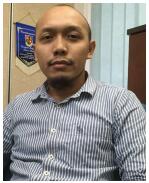
Malaysia: Dr. Muhammad Zulkarnain bin Abd Rahman, Universiti Teknologi Malaysia (UTM)
|
| Dr. Muhammad Zulkarnain bin Abdul Rahman is a senior lecturer at Department of Geoinformation, Faculty of Geoinformation and Real Estate, Universiti Teknologi Malaysia (UTM). His current research focuses on hazard and risk studies on flood and landslide, flood modelling and mitigation measures, laser remote sensing for forest management as well as methods and algorithms for point clouds processing |
Malaysia has been long hit by floods, which caused severe loss in economic resources and human lives. Several mitigation measures have been proposed and implemented to reduce the hazard and risk but the process become very complicated due to overpopulated environment of the flood prone area, less efficient early warning system and lack of coordination in emergency response. Drought and flood has been proposed as one of the tasks under the Working Group of the DBAR-WATER Theme. This initiative and cooperation can significantly help Malaysia in many aspects to reduce flood hazard and risk. Furthermore, such cooperation will be able to strengthen the non-structural approach of flood mitigation measures that mainly aims at enhancing community awareness on hazard and risk as well as introducing efficient community-based local coping mechanism in reducing flood risk. Such approach and valuable information can be shared among the countries within the Belt and Road regions. The initiative should also extend the task towards development of a comprehensive flood hazard and risk mapping that is highly required at different stages in disaster and risk management cycle, i.e. prevention and mitigation, preparedness, response and recovery. Detailed impact of flood and drought analysis should also be done on local types of elements-atrisk i.e. different types of crops, buildings and other land use classes. This might be very useful to improve vulnerability models for an efficient flood and drought risk analysis and mapping. One of the issues in water related studies for developing countries is the quality of remotely sensed data. Acquisition of high quality remotely sensed data has always been hindered by limited funding. Therefore suitable and sustainable remote sensing technologies and method still requires further investigation for water related application, such as foreseen under DBAR-WATER.

