


2. 中国科学院青藏高原研究卓越中心 北京 100101;
3. 中国科学院大学 北京 100049;
4. 中国科学院地球环境研究所 西安 710061;
5. 香港大学 地球科学系 香港 999077;
6. 中国科学院遥感与数字地球研究所 北京 100094
2. Center for Excellence in Tibetan Plateau Earth Sciences, Chinese Academy of Sciences, Beijing 100101, China;
3. University of Chinese Academy of Sciences, Beijing 100049, China;
4. Institute of Earth Environment, Chinese Academy of Sciences, Xi'an 710061, China;
5. Department of Earth Sciences, The University of Hong Kong, Hong Kong 999077, China;
6. Institute of Remote Sensing and Digital Earth, Chinese Academy of Sciences, Beijing 100094, China
亚洲内陆是北半球最大、最广阔的中纬度干旱区(图 1),从空间上横跨了蒙古国中南部、中国黄土高原以北和西北三大内陆盆地以及中亚的干旱区,也是陆上丝绸之路穿越的重要地区。这一干旱区不同于世界上分布于副热带高压控制下的干旱区(如著名的非洲撒哈拉沙漠以及中东的沙漠),而是分布于中纬度地区;相反,本应该是副热带高压控制下的长江中下游地区却因亚洲季风的影响,成为降水丰沛的“鱼米之乡”。

|
| 图 1 现今亚洲中纬度干旱区的地理位置 |
现今的亚洲中纬度干旱区深居内陆,远离各大洋的水汽来源(图 1)。其中,印度洋的水汽被喜马拉雅山脉阻挡;来自太平洋的水汽在经过长途跋涉之后,在抵达中亚干旱区之前基本耗尽;而来自大西洋和地中海的西风带水汽在欧洲大陆上空也大部分耗尽,有限的水汽又受到帕米尔高原、兴都库什、天山山脉、阿尔泰山脉的阻挡。因此,亚洲中纬度地区成为了北半球最广阔的干旱区。
亚洲中纬度干旱区究竟如何逐步发展为现今的荒漠景观?这历经了怎样的干旱化过程?其形成演化的动力机制是什么?新生代以来印度、阿拉伯、非洲板块与欧亚大陆的碰撞,青藏高原的隆升,新特提斯海的退却以及新生代全球气候变冷与海平面下降等区域和全球要素,究竟在亚洲中纬度干旱区的形成过程中各自扮演了怎样的角色?这些均是目前悬而未决的问题。
亚洲中纬度干旱区发展成今天所见的干旱荒漠,并不是短时间内实现的,而是经历了漫长的地质过程,而且也不是某些学者认为的该地区一直都是干旱环境。事实上,亚洲中纬度地区在地质过程中经历了阶段性演化的进程,是从半湿润—半干旱—干旱—极端干旱渐进演化而来。本文也主要尝试基于前人的研究基础,结合近年的研究结果,探讨亚洲中纬度干旱区的阶段性演化过程。
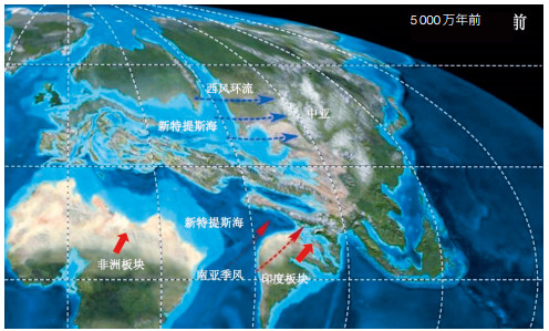
1 始新世时期半湿润的中亚古环境亚洲中纬度干旱区发展成现今的大范围干旱区,有其深刻的大地构造背景。我们知道地球上最近的一次超大陆汇聚发生在距今2.5亿年前的潘基亚超大陆时期,但从距今2.3亿年以来,潘基亚超大陆开始裂解。尤其是白垩纪末期(距今9 400万年)以来,南半球冈瓦纳大陆的裂解加剧,非洲、印度板块纷纷从南极洲板块脱离向北漂移。直至距今6 000万年前后,印度板块的前端已经与亚洲南缘沿着雅鲁藏布江缝合带的中段发生碰撞[1-3]。但是在印度板块与亚洲板块碰撞带的东、西构造结,一般认为碰撞较晚,直至距今5 000万年前后才完全碰撞[2]。不仅印度板块向北漂移,非洲板块同样北漂,二者与欧亚板块的汇聚,加速了新特提斯海的收缩。
距今5 000万年的早始新世时期(图 2),区域大地构造演化已经影响到中亚的古气候。最近的研究表明,印度次大陆自冈瓦纳大陆裂解以后,当漂过赤道,到达热带辐合带(Intertropical Convergence Zone,ITCZ)控制范围时,已经有南亚季风的形成,这已被早始新世的数值模拟所证实[4]。同时,Shukla和Mehrotra[5]在印度西北的拉贾斯坦邦发现了早始新世(距今5 500万年—5 200万年)指示气候湿润的煤系地层,且通过对大量阔叶植物化石的分析,表明当时的降水量可达1 800毫米/年,干、湿季节分明,这说明南亚季风有可能在距今5 000万年前后即已形成。
需要说明的是,印度与亚洲板块在距今5 000万年已经完全碰撞,碰撞边界的山脉隆升[7]至少会在一定程度上阻挡南亚季风深入亚洲大陆腹地。此外,尽管受非洲、印度板块与欧亚板块碰撞导致新特提斯海范围有所缩小,但是在现今的中亚地区及其以西地区仍然存在广阔的海域,西风环流可以将大量水汽带入中亚。
即使到了始新世晚期(距今4 000万年左右),海水才从塔里木盆地退出[8, 9],这也与Carrapa[10]认为在连通塔里木与塔吉克盆地的阿莱海峡最西端(塔吉克盆地的最东端)的海退时间为距今3 900万年前相吻合,因为处在阿莱海峡东部的塔里木盆地不应比这更晚。但是,晚始新世(距今4 000万年)海水从塔里木盆地的退出过程主要与帕米尔高原的向北突刺有关。此时,在帕米尔高原以西的塔吉克盆地大部及其以西地区仍有广阔的海洋。而且,此时的帕米尔高原并没有与南天山相撞,二者之间至少存在300公里的水汽通道[11],并且此时天山山脉尚未发生构造复活,仍保留中生代长期剥蚀后的低海拔[12],西风环流可以将来自大西洋和新特提斯海的水汽带入中亚。无论在塔里木盆地的苏维依组[13],还是准噶尔盆地的紫泥泉子组[14],都是以湖湘地层为主;更东边的蒙古国南部地区在晚始新世也是湖泊-河流相沉积环境[15]。这表明,这一时期的中亚至少是半湿润气候。
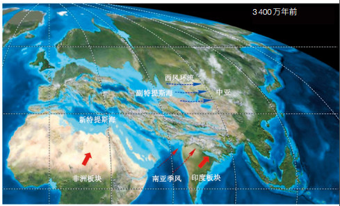
2 渐新世时期半湿润-半干旱为主的中亚古环境距今3 400万年的渐新世初期,非洲板块、印度板块与欧亚板块的汇聚加剧,直接的效应就是青藏高原的进一步隆升和新特提斯海的进一步收缩(图 3)。此外,渐新世初期也发生了新生代气候变冷进程中最重要的气候事件——南极冰盖开始形成,全球气候开始从“温室期”转变为“冰室期”,并伴随全球海平面的大幅下降。
渐新世初期,在大陆汇聚与全球变冷导致的海面下降的共同作用下,此前曾经联通在一起的新特提海被分割成南、北两个分支,其中,北支称为副特提斯海(Paratethys)(图 3)。由于印度板块与欧亚板块的持续碰撞,青藏高原中部的隆升高度在渐新世时期已经接近海拔3 000米的高度[16-18]。尽管有国外学者利用碳酸盐氧同位素古高度计认为高原中部在渐新世已经接近现今高度[19, 20],但是,无论是土壤碳酸盐或是湖泊碳酸盐氧同位素高度计都存在不可回避的问题——氧同位素分馏受水汽来源与碳酸盐成岩作用(重置)的影响很大,因此严重影响其可靠程度。青藏高原的隆升无疑会更有效阻挡南亚季风深入到亚洲腹地,其“雨影”效应已经十分显著。渐新世时期,东亚季风尚未形成[4, 21, 22],能够影响亚洲中纬度地区的水汽来源,基本只剩下西风环流的水汽[23]。
尽管渐新世初期的副特提斯海其范围较始新世时期缩小,但此时帕米尔仍未与南天山相撞,来自大西洋及副特提斯海的水汽通道尚未关闭[24]。而且,天山山脉也仍然是低海拔的山脉,尚未发生构造复活[12]。水汽依然能够被盛行的西风带到中亚。但由于上风方向水汽范围的减少,被西风环流带入亚洲中纬度干旱区的水汽相应减少,导致亚洲腹地开始出现半干旱气候。在距离副特提斯海水汽来源最远的蒙古国南部,渐新世初期开始出现风成的红黏土沉积[15]。
然而,在蒙古国出现的渐新世风成红黏土夹有古土壤和碳酸盐结核层,这表明当时的亚洲中纬度地区至少是半干旱气候,而不是极端干旱气候。众所周知,成土碳酸盐结核的形成必须有足够水分化学淋溶作用,因此,成土碳酸盐结核的存在说明当时并不是极端干旱气候。而且在蒙古国的区域地质调查中,也并未发现任何的古沙丘沉积,上述渐新世红黏土沉积为风力从山前洪积扇、干旱的古河道等搬运而来。
在渐新世末期前后,黄土高原的六盘山以西以及新疆准噶尔盆地也开始出现风成的红黏土沉积[21, 25, 26]。这些地区的风成红黏土同样夹有古土壤和碳酸盐结核,这证明其经过足够水分的化学淋溶作用,并且其本身是粉尘堆积,而不是风沙沉积,其沉积环境应当为草原-干草原的半湿润-半干旱环境。
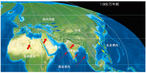
3 晚中新世以来趋于干旱的中亚古环境晚中新世以来,不仅印度与亚洲板块的碰撞持续进行,阿拉伯板块也在晚中新世与亚洲板块碰撞导致伊朗高原的隆升[27, 28],同时非洲板块也持续与欧亚板块汇聚,二者进一步加剧了副特提斯海的退缩。此外,自距今1 400万年以来由于东南极冰盖的持续扩张[29],海平面也持续下降。在板块汇聚和全球变冷的共同作用下,曾经烟波浩渺的副特提斯海在晚中新世已经大幅退缩(图 4)。
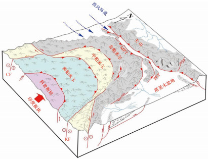
而且更为重要的是,大量地质证据表明,在晚中新世(距今700万年—500万年),帕米尔高原的前端(北帕米尔)与南天山相撞,帕米尔前缘断裂开始活动[30-33],逐渐关闭了进入塔里木盆地的水汽通道(图 5),加速了塔里木盆地极端干旱气候的出现。这一时期,尽管在塔里木盆地中部的麻扎塔格剖面和罗布泊钻孔仍然显示出以湖泊沉积为主的特征[33, 34],但在塔里木腹地的麻扎塔格剖面中显示此时已有零星的古风成砂夹层出现在晚中新世的湖湘地层中,这指示塔里木盆地极端干旱气候开始出现。尽管塔里木盆地的干旱历史仍有争议[35-38],但更多的证据表明更干旱的气候出现在距今500万年以来[33, 34, 39-41]。这一时期塔里木盆地的湖湘地层消失,代之以河流相与古风成砂相为主的沉积,塔里木盆地进一步向极端干旱气候迈进。同时,这也与柴达木盆地发现的骨骼超常粗大的伍氏献文鱼化石指示的上新世以来柴达木盆地干旱化加剧的地质记录[42],以及中亚其他地区的晚中新世干旱化加剧的证据相印证[43]。
尽管我们现在并不清楚,中国的其他沙漠,如巴丹吉林、腾格里、乌兰布和、库布齐、毛乌素沙漠等,何时形成;但是中国黄土高原六盘山以东广泛分布的距今800万年—700万年以来的第三纪风成红黏土[44-48],指示了这一时期,其物源区的中亚干旱-半干旱区已经初具规模。
| [1] | DeCelles P, Kapp P, Gehrels G, et al. Paleocene-Eocene foreland basin evolution in the Himalaya of southern Tibet and Nepal:implications for the age of initial India-Asia collision. Tectonics, 2014, 33(5): 824–849. DOI:10.1002/2014TC003522 |
| [2] | Wu F Y, Ji W Q, Wang J G, et al. Zircon U-Pb and Hf isotopic constraints of the onset time of India-Asia collision. American Journal of Science, 2014, 314: 548–579. DOI:10.2475/02.2014.04 |
| [3] | Hu X, Garzanti E, Moore T, et al. Direct stratigraphic dating of India-Asia collision onset at the Selandian (middle Paleocene, 59±1 Ma). Geology, 2015, 43: 859–862. DOI:10.1130/G36872.1 |
| [4] | Liu X D, Dong B W, Yin Z Y, et al. Continental drift and plateau uplift control origination and evolution of Asian and Australian monsoons. Scientific Reports, 2017, 7: 40344. DOI:10.1038/srep40344 |
| [5] | Shukla A, Mehrotra A C. Early Eocene (~50 Myr) legume fruits from Rajasthan. Current Science, 2016, 111: 465–467. |
| [6] | Blakey R. Global paleogeography.[2017-09-13]. http://jan.ucc.nau.edu/rcb7/. |
| [7] | Ding L, Xu Q, Yue Y H, et al. The Andean-type Gangdese Mountains:Paleoelevation record from the Paleocene-Eocene Linzhou Basin. Earth and Planetary Science Letters, 2014, 392: 250–264. DOI:10.1016/j.epsl.2014.01.045 |
| [8] | Bosboom R E, Dupont-Nivet G, Grothe A, et al. Linking Tarim Basin sea retreat (West China) and Asian aridification in the late Eocene. Basin Research, 2014, 26: 621–640. DOI:10.1111/bre.12054 |
| [9] | Sun J M, Windley B F, Zhang Z L, et al. Diachronous seawater retreat from the southwestern margin of the Tarim Basin in the late Eocene. Journal of Asian Earth Sciences, 2016, 116: 222–231. DOI:10.1016/j.jseaes.2015.11.020 |
| [10] | Carrapa B, DeCelles P G, Wang X, et al. Tectono-climatic implications of Eocene Paratethys regression in the Tajik basin of central Asia. Earth and Planetary Science Letters, 2015, 424: 168–178. DOI:10.1016/j.epsl.2015.05.034 |
| [11] | Burtman V S, Molnar P. Geological and geophysical evidence for deep subduction of continental crust beneath the Pamir. Geological Society of America Special Paper, 1993, 281: 1–76. DOI:10.1130/SPE281 |
| [12] | Tapponnier P, Molnar P. Active faulting and Cenozoic tectonics of the Tien Shan, Mongolia and Baykal regions. Journal of Geophysical Research, 1979, 84(B7): 3425–3459. DOI:10.1029/JB084iB07p03425 |
| [13] | Zhang Z L, Shen Z Y, S un, J M, et al. Magnetostratigraphy of the Kelasu section in the Baicheng depression, Southern Tian Shan, northwestern China. Journal of Asian Earth Sciences, 2015, 111: 492–504. DOI:10.1016/j.jseaes.2015.06.016 |
| [14] | 新疆维吾尔自治区地质矿产局. 新疆维吾尔自治区区域地质志. 北京: 地质出版社, 1993. |
| [15] | Sun J M, Windley B. Onset of aridification by 34 Ma across the Eocene-Oligocene transition in Central Asia. Geology, 2015, 43: 1015–1018. DOI:10.1130/G37165.1 |
| [16] | Deng T, Wang S Q, Xie G P, et al. Amammalian fossil from the Dingqing Formation in the Lunpola Basin, northern Tibet, and its relevance to age and paleo-altimetry. Chinese Science Bulletin, 2012, 57: 261–269. DOI:10.1007/s11434-011-4773-8 |
| [17] | Sun J M, Xu Q H, Liu W M, et al. Palynological evidence for the latest Oligocene-early Miocene paleoelevation estimate in the Lunpola Basin, central Tibet. Palaeogeography, Palaeoclimatology, Palaeoecology, 2014, 399: 21–30. DOI:10.1016/j.palaeo.2014.02.004 |
| [18] | Jia G D, Bai Y, Ma Y J, et al. Paleoelevation of Tibetan Lunpola basin in the Oligocene-Miocene transition estimated from leaf wax lipid dual isotopes. Global and Planetary Change, 2015, 126: 14–22. DOI:10.1016/j.gloplacha.2014.12.007 |
| [19] | Rowley D B, Currie B S, et al. Palaeo-altimetry of the late Eocene to Miocene Lunpola basin, central Tibet. Nature, 2006, 439: 677–681. DOI:10.1038/nature04506 |
| [20] | Polissar P J, Freeman K H, Rowley D B, et al. Paleoaltimetry of the Tibetan Plateau from D/H ratios of lipid biomarkers. Earth and Planetary Science Letters, 2009, 287: 64–76. DOI:10.1016/j.epsl.2009.07.037 |
| [21] | Guo Z T, Ruddiman W F, Hao Q Z, et al. Onset of Asian desertification by 22 Myr ago inferred from loess deposits in China. Nature, 2002, 416: 159–163. DOI:10.1038/416159a |
| [22] | Sun X J, Wang P X. How old is the Asian monsoon system? Palaeobotanical records from China. Palaeogeography, Palaeoclimatology, Palaeoecology, 2005, 222: 181–222. DOI:10.1016/j.palaeo.2005.03.005 |
| [23] | Caves J K, Winnick M J, Graham S A, et al. Role of the westerlies in Central Asia climate over the Cenozoic. Earth and Planetary Science Letters, 2015, 428: 33–43. DOI:10.1016/j.epsl.2015.07.023 |
| [24] | Cowgill E, Yin A, Harrison T M, et al. Reconstruction of the Altyn Tagh Fault based on U-Pb geochronology:Role of back thrusts, mantle sutures, and heterogeneous crustal strength in forming the Tibetan Plateau. Journal of Geophysical Research, 2003, 108: 2346. |
| [25] | Sun J M, Ye J, Wu W Y, et al. Late Oligocene-Miocene midlatitude aridification and wind patterns in the Asian interior. Geology, 2010, 38: 515–518. DOI:10.1130/G30776.1 |
| [26] | Qiang X K, An Z S, Song Y G, et al. New eolian red clay sequence on the western Chinese Loess Plateau linked to onset of Asian desertification about 25 Ma ago. Science China Earth Science, 2011, 54: 136–144. |
| [27] | Mouthereau F, Lacombe O, Vergés J. Building the Zagros collisional orogen:Timing, strain distribution and the dynamics of Arabia/Eurasia plate convergence. Tectonophysics, 2012, 532-535: 27–60. DOI:10.1016/j.tecto.2012.01.022 |
| [28] | Gavillot Y, Axen G J, Stockli D F, et al. Timing of thrust activity in the High Zagros fold-thrust belt, Iran, from (U-Th)/He thermochronometry. Tectonics, 2010, 29(4): 253–274. |
| [29] | Zachos J, Pagani M, Sloan L, et al. Trends, rhythms, and aberrations in global climate 65 Ma to present. Science, 2001, 292: 686–693. DOI:10.1126/science.1059412 |
| [30] | Fu B H, Ninomiya Y, Guo J M. Slip partitioning in the northeast Pamir-Tian Shan convergence zone. Tectonophysics, 2010, 483: 344–364. DOI:10.1016/j.tecto.2009.11.003 |
| [31] | Cao K, Wang G, van der Beek P, et al. Cenozoic thermo-tectonic evolution of the northeastern Pamir revealed by zircon and apatite fission-track thermochronology. Tectonophysics, 2013, 589: 17–32. DOI:10.1016/j.tecto.2012.12.038 |
| [32] | Thompson J A, Burbank D W, Tao L, et al. Late Miocene northward propagation of the northeast Pamir thrust system, northwest China. Tectonics, 2015, 34: 510–534. DOI:10.1002/2014TC003690 |
| [33] | Sun J M, Liu W G, Liu Z H, et al. Extreme aridification since the beginning of the Pliocene in the Tarim Basin, western China. Palaeogeography, Palaeoclimatology, Palaeoecology, 2017 (in press). |
| [34] | Liu W G, Liu Z H, An Z S, et al. Late Miocene episodic lakes in the arid Tarim Basin, western China. PNAS, 2014, 111: 16292–16296. DOI:10.1073/pnas.1410890111 |
| [35] | Fang X M, Lü L Q, Yang S L, et al. Loess in Kunlun Mountains and its implications on desert development and Tibetan Plateau uplift in west China. Science China (Series D), 2002, 45: 289–299. |
| [36] | Sun D H, Bloemendal J, Yi Z Y, et al. Palaeomagnetic and palaeoenvironmental study of two parallel sections of late Cenozoic strata in the central Taklimakan Desert:implications for the desertification of the Tarim Basin. Palaeogeography, Palaeoclimatology, Palaeoecology, 2011, 300: 1–10. DOI:10.1016/j.palaeo.2010.11.015 |
| [37] | Sun J M, Alloway B, Fang X, et al. Refuting the evidence for an earlier birth of the Taklimakan Desert. PNAS, 2015, 112: 5556–5557. DOI:10.1073/pnas.1505168112 |
| [38] | Zheng H B, Wei X C, Tada R, et al. Late Oligocene-early Miocene birth of the Taklimakan Desert. PNAS, 2015, 112: 7662–7667. DOI:10.1073/pnas.1424487112 |
| [39] | Sun J M, Liu T S. The age of the Taklimakan Desert. Science, 2006, 312: 1621. DOI:10.1126/science.1124616 |
| [40] | Chang H, An Z S, Liu W G, et al. Magnetostratigraphic and paleoenvironmental records for a late Cenozoic sedimentary sequence drilled from Lop Nur in the eastern Tarim Basin. Global Planetary Chang, 2012, 80-81: 113–122. DOI:10.1016/j.gloplacha.2011.09.008 |
| [41] | Sun J M, Gong Z J, Tian Z H, et al. Late Miocene stepwise aridification in the Asian interior and the interplay between tectonics and climate. Palaeogeography, Palaeoclimatology, Palaeoecology, 2015, 421: 48–59. DOI:10.1016/j.palaeo.2015.01.001 |
| [42] | Chang M M, Wang X M, Liu H Z, et al. Extraordinarily thickboned fish linked to the aridification of the Qaidam Basin (northern Tibetan Plateau). PNAS, 2008, 105: 13246–13251. DOI:10.1073/pnas.0805982105 |
| [43] | Caves J K, Bayshashov B U, Zhamangara A, et al. Late Miocene Uplift of the Tian Shan and Altai and Reorganization of Central Asia Climate. GSA Today, 2016, 27(2). DOI:10.1130/GSATG305A.1 |
| [44] | Ding Z L, Sun J M, Liu T S, et al. Wind-blown origin of the Pliocene red clay formation in central Loess Plateau, China. Earth and Planetary Science Letters, 1998, 161: 135–143. DOI:10.1016/S0012-821X(98)00145-9 |
| [45] | Ding Z L, Sun J M, Yang S L, et al. Preliminary magnetostratigraphy of a thick eolian red clay-Loess sequence at Lingtai, the Chinese Loess Plateau. Geophysical Research Letters, 1998, 25: 1225–1228. DOI:10.1029/98GL00836 |
| [46] | Sun D H, Shaw J, An Z S, et al. Magnetostratigraphy and paleoclimatic interpretation of a continuous 7.2 Ma Late Cenozoic eolian sediments from the Chinese Loess Plateau. Geophysical Research Letters, 1998, 25: 85–88. DOI:10.1029/97GL03353 |
| [47] | An Z S, Kutzbach J E, Prell W L, et al. Evolution of Asian monsoons and phased uplift of the Himalaya-Tibetan plateau since Late Miocene times. Nature, 2001, 411: 62–66. DOI:10.1038/35075035 |
| [48] | Guo Z T, Peng S Z, Hao Q Z, et al. Late Miocene-Pliocene development of Asian aridification as recorded in an eolian sequence in northern China. Global and Planetary Changes, 2004, 41(3-4): 135–145. DOI:10.1016/j.gloplacha.2004.01.002 |